
 English
 norsk
norskInstitutt for geovitenskap: Nye registreringer
Viser treff 881-900 av 1121
-
Removal of methane through hydrological, microbial, and geochemical processes in the shallow sediments of pockmarks along eastern Vestnesa Ridge (Svalbard)
(Journal article; Tidsskriftartikkel; Peer reviewed, 2016)The recent discovery of methane seeps in the Arctic region requires a better understanding of the fate of methane in marine sediments if we are to understand the contributions of methane to Arctic ecosystems and climate change. To further this goal, we analyze pore water data from five pockmarks along eastern Vestnesa Ridge, a sediment drift northwest of Svalbard, to quantify the consumption ... -
Structural and metamorphic implications of the final emplacement of the Lyngen Nappe
(Master thesis; Mastergradsoppgave, 2017-06-15)The Lyngen Nappe, an allochthonous unit of the Northern Norwegian Caledonides, consists of Greenschist-facies rocks overlying Amphibolite- to Granulite-facies rocks in the Nordmannvik Nappe. The lower-grade metamorphism seen in the Lyngen rocks juxtaposes higher-grade rocks both above and below. The nature and origin of this metamorphic break is investigated, specifically in the sheared rock units ... -
Stress distribution calculations through a snow slab of varying hardness. Comparison with stability evaluation in the field
(Master thesis; Mastergradsoppgave, 2017-05-05)Field observations are the main tools for assessing the snow stability concerning dry snow slab avalanche release. Often, theoretical studies cannot directly be translated into useful information for avalanche recreationists and forecasters in the field, and vice versa; field observations are not always objective and quantifiable for theoretical studies. Moreover, numerical models often oversimplify ... -
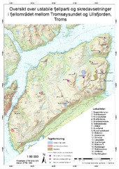
Geomorfologisk og strukturgeologisk undersøking av ustabile skråningar og skredavsettingar. Regional analyse av fjellområdet mellom Tromsøysundet og Ullsfjorden -Troms, Norge.
(Master thesis; Mastergradsoppgave, 2017-05-15)Samandrag Troms er det fylket i landet med flest registrerte ustabile fjellsider. Ved å kartlegga større områder for ustabile fjellparti og historiske skred, kan ein gjera ei regional analyse. Dette kan bidra til å forstå dei styrande faktorane for utrasing i eit regionalt perspektiv. Denne avhandlinga omhandlar hovudsakleg geomorfologi, og er skreve parallelt med Andreas Grumstad som har omtala ... -
Reconstruction of late Holocene paleoenvironment in Kongsfjorden, West Spitsbergen. Based on analysis of benthic foraminifera
(Master thesis; Mastergradsoppgave, 2017-05-15)The benthic foraminiferal fauna of two marine sediment records from the Kongsfjorden Trough and the inner part of Kongsfjorden were analyzed to reconstruct the paleoenvironmental development throughout the last ~ 2000 years. A generally cold period is evident in both records, lasting from ~ 700 to 1400 CE at the Kongsfjorden Trough and from ~ 350 to 1200 CE in the inner part of Kongsfjorden, with ... -
Paleoceanographic Development in Nordfjord, North East Greenland, During the Mid- and Late Holocene
(Master thesis; Mastergradsoppgave, 2017-05-15)Sediment core HH13-012GC-TUNU, retrieved from Nordfjord, North-East Greenland, has been investigated in order to reconstruct the paleoceanographic development during the mid- and late Holocene. Nordfjord is one of three tributary fjords to Kaiser Franz Joseph Fjord, and Waltershausen Gletcher is located at its head. The fjord system is largely influenced by the Eastern Greenland Current. Most of ... -
Processing and interpretation of the Svyatogor 2016 high-resolution P-Cable 3D seismic dataset. Investigating the dynamics of a sub-seabed gas hydrate system with a potential abiotic methane source
(Master thesis; Mastergradsoppgave, 2017-06-01)A new high-resolution P-Cable 3D seismic dataset was acquired in July 2016 targeting a seafloor pockmark cluster at the northern end of Svyatogor Ridge, offshore west Svalbard. The processing and interpretation of this dataset formed the primary focus of this thesis. The seismic processing sequence was designed to enhance the signal-to-noise ratio of the data while preserving the useful signal ... -
Exploratory data analysis of flexural waves in Arctic fjord ice seismic data
(Master thesis; Mastergradsoppgave, 2017-05-14)A seismic source on floating ice induces flexural waves in the ice layer. An exploratory data analysis of Arctic fjord ice seismic data is performed for the purpose of identifying and studying characteristics of flexural waves and other related wave modes. Both geophone and hydrophone data are examined with the purpose of studying ice properties from ice wave behavior. Power spectral density estimates ... -
Glacial history and geomorphology of Trygghamna, western Svalbard
(Master thesis; Mastergradsoppgave, 2017-05-15)This study investigates Trygghamna, a small fjord on the western coast of Spitsbergen, Svalbard. In order to investigate its glacial history, high-resolution aerial images and swath bathymetry are used to produce a detailed geomorphological map of the area, with a focus on the Neoglacial extent of the three largest glaciers in the fjord, Protektor-, Harriet- and Kjerulfbreen. The landforms are ... -
Geomorfologisk kartlegging av Kjosen, Lyngen, Troms. Med fokus på snøskredavsetninger på Sultinden og Tytebærdalen
(Master thesis; Mastergradsoppgave, 2017-05-15)Snøskred er et utbredt faremoment i Norge og Troms, og har de siste årene tatt flere menneskeliv. Det investeres store ressurser i beskyttelsestiltak, og behovet for å forstå snøskred – hvor og når de kan inntreffe – vokser i takt med samfunnsutvikling og klimaendringer. Kjosen i Lyngen er utsatt for skred hvert år, og det har gått både hus og menneskeliv tapt her. Snøskred er også en geomorfologisk ... -
Geomorfologisk undersøkelse av skredvifter i Indre Kjosen, Lyngen, Troms, med fokus på snøskredavsetninger
(Master thesis; Mastergradsoppgave, 2017-05-16)Skred er et utbredt faremoment i Troms og utgjør en overhengende trussel for bebyggelse så vel som for infrastruktur. Skredene kan skade mennesker og menneskelige interesser, og det investeres store summer i sikringstiltak. Skredprosesser er med på å utvikle landskapet og kan spores på bakgrunn av mer eller mindre karakteristiske landformer, elementer og avsetninger, kalt skredindikatorer. ... -
Heinrich events of the late Pleistocene; evidence from a sediment core west of Jan Mayen. An analogue to present day ice sheet collapse?
(Master thesis; Mastergradsoppgave, 2017-05-15)A thorough lithological investigation of deep sea sediment core HH13-100GC has been undertaken, in order to investigate the climate and oceanographic fluctuations of the last glacial epoch. The cause of Heinrich events has remained an enigma ever since the discovery of Heinrich layers in the North Atlantic in the 1980s. Through a combination of XRF and X-ray imagery, geotechnical property investigation, ... -
The occurrence of flow transformations within sandy submarine fans: A case study from the Eocene on Spitsbergen
(Master thesis; Mastergradsoppgave, 2017-05-15)The Van Keulenfjorden transect on Spitsbergen offers valuable insight into submarine processes, with well exposed seismic scale clinoforms of Paleocene and Eocene age, which show the distribution of sediments from deltaic to basin floor environments. Several progradational submarine fans are preserved as cliffs on Hyrnestabben. They serve as an analogues to coarse grained submarine fans in provinces ... -
Investigating the variability of Atlantic water inflow to the southwestern Barents Sea through Bjørnøyrenna during the Late Glacial and Holocene based on benthic foraminifera and sediment properties.
(Master thesis; Mastergradsoppgave, 2017-05-15)This study is a part of the Barents Sea drill cuttings research initiative (BARCUT), investigating the inflow of Atlantic water to the southwestern Barents Sea during the Late Glacial and Holocene as well as providing data for future references. -
Study of millennial scale paleoclimatic and paleoceanographic changes in conjunction with variations in the East Greenland Current during the late Quaternary
(Master thesis; Mastergradsoppgave, 2017-05-15)Sediment core HH13-089GC (497 cm), collected from the continental slope off Scoresby Sund, East Greenland has been investigated in order to study paleoclimatic and paleoceanographic changes in the area in conjunction with variations in the East Greenland Current during the late Quaternary. The results are based on a multiproxy analysis of the sediment core, including faunal investigations of planktic- ... -
Sedimentological and geomorphological study of a postglacial fjord-side landslide and fan-delta complex at Russenes, inner Balsfjord, Troms county
(Master thesis; Mastergradsoppgave, 2017-05-15)A comprehensive study of the Russenes postglacial fjord-side fan delta and landslide complex has been undertaken in inner Balsfjord, Troms county, northern Norway. High-resolution bathymetric data, digital terrain models, aerial photography, ground penetrating radar profiling, radiocarbon dating and field mapping have been used to determine the geometry, structure, lithofacies and evolution of the ... -
Sedimentary environment and seismic anomalies of the upper Brygge and Kai formations on the northern part of the Mid-Norwegian Continental Shelf
(Master thesis; Mastergradsoppgave, 2017-05-15)The sedimentary environment and seismic anomalies of the upper Brygge and Kai formations on the northern part of the Mid-Norwegian Continental Shelf is analysed from 3D seismic data and the exploration well 6604/2-1. This was done in order to give a better understanding of the paleo-climatic development in the period before the establishment of the large-scale ice sheets of the Northern Hemisphere, ... -
Geomorfologisk analyse og skredkartlegging av Setså-området i Saltdal kommune, Nordland
(Master thesis; Mastergradsoppgave, 2017-05-14)Det norske fjord- og dallandskapet består høye fjell og bratte dalsider som er preget av skredaktivitet. Økende krav til framkommelighet langs vegnettet fører til at infrastrukturen er i stadig utvikling, og i mange tilfeller må vegbanen flyttes til mer skredsikre områder. Statens vegvesen er i gang med arbeidet for å flytte dagens Europaveg 6 gjennom Setså, Saltdal kommune, Nordland bort fra de ... -
Geomorfologisk og strukturgeologisk undersøkelse av ustabile skråninger og skredavsetninger i fjellområdet mellom Tromsøysundet og Ullsfjorden i Tromsf
(Master thesis; Mastergradsoppgave, 2017-05-15)Fjellskred er den naturkatastrofen i landet som kan gi høyest konsekvenser, og Troms fylke har flere registrerte ustabile fjellsider enn noe annet sted i landet. Dette gjør også at mange skred og ustabile fjellsider kan studeres innenfor et relativt lite geografisk område. Hensikten med denne oppgaven er å finne sammenhenger i parameterer i berggrunn og topografi som er med å initiere bevegelse i ... -
Integrated characterization of igneous intrusions in Central Spitsbergen
(Master thesis; Mastergradsoppgave, 2017-05-15)Igneous intrusions have a strong influence on petroleum systems, groundwater aquifers, and CO2 storage reservoirs, particularly because they can act as either barriers to, or carriers for fluid flow. This depends on several syn- and post emplacement processes, including fracture development in the intrusion and the host rocks, contact metamorphism of the host rocks, and hydrothermal activity. ...